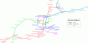
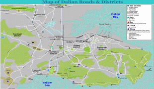
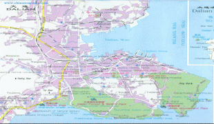
Dalian
As of the 2020 census, its total population was 7,450,785 inhabitants whom 5,106,719 lived in the built-up (or metro) area made of 6 out of 7 urban districts, Pulandian District not being conurbated yet.
Today a financial, shipping, and logistics center for East Asia, Dalian has a significant history of being used by foreign powers for its ports. Dalian was previously known as "Dalniy" (Дальний; Dal'nii), "Dairen" (大連), and "Lüda" or "Luta". The city used to be better known as "Port Arthur" and "Ryojun" (旅順) from the original Port Arthur, now the city's Lüshunkou district.
In 2016, Dalian ranked 48th in the Global Financial Centres Index. In 2012, Dalian ranked 82nd in the Global City Competitiveness Index. In 2006, Dalian was named China's most livable city by China Daily. It is now a "Beta - Global City" according to the Globalization and World Cities Research Network. The large amount of port traffic makes Dalian a Large-Port Metropolis.
Dalian is one of the top 50 science cities in the world by scientific research as tracked by the Nature Index, ranking 49th in the world as of 2022. The city is home to several major universities, notably Dalian University of Technology and Dalian Maritime University, members of China's prestigious universities in the Project 211, and the Dalian Institute of Chemical Physics of the Chinese Academy of Sciences.
Modern Dalian originated from Qingniwa or Qingniwaqiao, a small Chinese fishing village. The Russian Empire built a commercial town after coercing a lease of the area from the Qing dynasty in 1898 and called it "Dalniy" (Дальний — "a remote one" or "far-away", in reference to the town's location, rendered as ) from 1898 to 1905. After the Russo-Japanese War of 1904–1905, Japan occupied the area as the Kwantung Leased Territory and renamed the city Dairen (大連/だいれん) after the Chinese name for Dalian Bay — a name in use since at least 1879. English-language sources called the city "Dairen" in this period (1905-1945), from Japanese.
In 1950 Dalian, back in Chinese control, merged with the nearby town called Lüshun (formerly "Ryojun" and before that, "Port Arthur") to form the city of Lüda, a name (formed from the first syllable of each constituent's name) which was usually rendered as Luta in English during that era. In 1981, the Chinese State Council again renamed the city, from Lüda back to "Dalian", effective 5 March 1981.
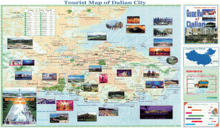
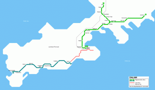
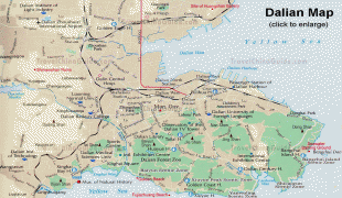
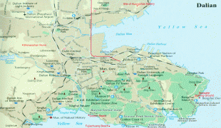
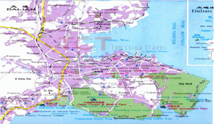
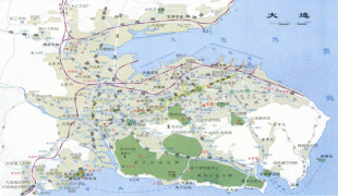
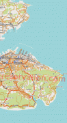
Map - Dalian
Map


Country - China
 |
 |
| Flag of China | |
Modern Chinese trace their origins to a cradle of civilization in the fertile basin of the Yellow River in the North China Plain. The semi-legendary Xia dynasty in the 21st century BCE and the well-attested Shang and Zhou dynasties developed a bureaucratic political system to serve hereditary monarchies, or dynasties. Chinese writing, Chinese classic literature, and the Hundred Schools of Thought emerged during this period and influenced China and its neighbors for centuries to come. In the third century BCE, Qin's wars of unification created the first Chinese empire, the short-lived Qin dynasty. The Qin was followed by the more stable Han dynasty (206 BCE–220 CE), which established a model for nearly two millennia in which the Chinese empire was one of the world's foremost economic powers. The empire expanded, fractured, and reunified; was conquered and reestablished; absorbed foreign religions and ideas; and made world-leading scientific advances, such as the Four Great Inventions: gunpowder, paper, the compass, and printing. After centuries of disunity following the fall of the Han, the Sui (581–618) and Tang (618–907) dynasties reunified the empire. The multi-ethnic Tang welcomed foreign trade and culture that came over the Silk Road and adapted Buddhism to Chinese needs. The early modern Song dynasty (960–1279) became increasingly urban and commercial. The civilian scholar-officials or literati used the examination system and the doctrines of Neo-Confucianism to replace the military aristocrats of earlier dynasties. The Mongol invasion established the Yuan dynasty in 1279, but the Ming dynasty (1368–1644) re-established Han Chinese control. The Manchu-led Qing dynasty nearly doubled the empire's territory and established a multi-ethnic state that was the basis of the modern Chinese nation, but suffered heavy losses to foreign imperialism in the 19th century.
Currency / Language
| ISO | Currency | Symbol | Significant figures |
|---|---|---|---|
| CNY | Renminbi | ¥ or 元 | 2 |
| ISO | Language |
|---|---|
| ZH | Chinese language |
| UG | Uighur language |
| ZA | Zhuang language |